
Pronóstiko di tempu pa Kòrsou i bisindario bálido te djárason mainta 06:00 o.l., 13 di yüli 2022.

Kinderdagverblijf en Naschoolse Opvang & Activiteiten
* Gekwalificeerde groepsleidsters
* Uw baby vanaf 6 weekjes oud
* Gevarieerde educatieve activiteiten
* Maandelijkse thema’s
* Het hele jaar door geopend
Bel of stuur een whatsapp bericht naar het nummer 5123160 voor nadere informatie en inschrijving
Klik hier oom naar onze FaceBook te gaan:
https://www.facebook.com/profile.php?id=100045700818054

Pronóstiko
Pronóstiko di tempu pa Kòrsou i bisindario bálido te djárason mainta 06:00 o.l., 13 di yüli 2022.
Kompilá: djamars 12 di yüli 2022, 05:00 o.l. (09:00 UTC).
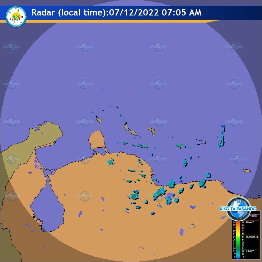
Tempu: Bientu lo sigui de bes en kuando fuerte i shelu lo ta de bes en kuando basta nublá ku chèns pa un áwaseru lokal den oranan di awe mainta. Pa sobra di dia e wer lo ta generalmente seku.
Temperatura máksimo lo alkansá 30ºC i temperatura mínimo 26ºC.
Solo ta sali 06:18 i ta baha 19:05 o.l.
Bientu: For di suitost te ost i moderá; forsa 3 te 5 (12 te 39 km/ora, 7 te 21 nudo). Ráfaga, de bes en kuando posiblemente fuerte; forsa 6 (40 te 50 km/ora, 22 te 27 nudo).
Situashon general: Un sistema di preshon haltu riba Atlántiko ta sigui dominá e tempu a traves di e region Karibense, e fluho di bientu lo kontinuá temporalmente fuerte durante di dia awe lo sòru pa laman bira lokalmente un poko mas brutu. Adishonalmente, oumento di humedat durante oranan di mainta por okashoná lokalmente algu di yobida di durashon kòrtiku riba partinan di Kòrsou. Mas lat den di dia, un shelu seku i árido lo kubri nos region, miéntras un disturbio lo kousa de bes en kuando pa nubianan na nivel haltu di atmósfera krusa nos área. Ademas, stòf prosedente di Sahara lo tene e bista un poko redusí.
Kondishon di laman: Generalmente moderá ku altura di olanan entre 1 i 1.5 meter (3 i 5 pia).
Sistemanan tropikal signifikante: Ningun
Fenómeno spesial: Ningun.
Perspektiva te djaweps mainta: Parsialmente nublá i no ta antisipá áwaseru signifikante.
Meteorólogo: Correa.


MARINE WEATHER FORECAST
| ISSUED: July 12, 2022. |
.
MARINE FORECAST FOR SEAS AROUND CURAÇAO:
.
| Synopsis: | The Atlantic high weakened somewhat and allows the local winds and seas to subside. Still, it supports an moderate to strong tradewinds with wave action to about 6 foot over the exposed waters. |
| Weather: | Generally partly cloudy and a chance for some shower activity during the morning hours. Afterwards in the afternoon, it is expected to lessen. |
| Visibility: | 8 to 15 kilometer in moderate hazy condition. |
| Winds: | Southeasterly to easterly and gentle to fresh; force 3 to 5 (12 to 30 km/h, 11 to 21 knots). Occasionally fresh to strong in gusts; force 6 (31 to 50 km/h, 17 to 27 knots). |
| Seas: | Generally moderate with wave heights between 1 and 1.5 meter (3 and 5 feet). |
.
Local wind forecast for the next 48 hours:
Easterly and gentle to moderate; force 3 to 4 (12 to 30 km/h, 7 to 16 knots).
Occasional gusts to fresh; force 5 (31 to 39 km/h, 17 to 21 knots).
.
Synopsis…High pressure over the north-central Atlantic will
maintain moderate to fresh trade winds across the eastern
Caribbean, and fresh to strong trade winds in the central portion
of Caribbean through early Thursday. The fresh to strong trade winds
in the central portion will diminish in coverage by Thursday evening
and change little through Saturday night. Gentle to moderate east to
southeast winds in the northwestern Caribbean will increase to
moderate to fresh on Tuesday, then diminish to gentle winds on Friday.
East winds in the Gulf of Honduras will increase to strong on Tue
night and continue to pulse at night through Thursday.
.
Caribbean S of 15N between 68W and 72W including Gulf of Venezuela-
.TODAY…E winds 20 to 25 kt. Seas 6 to 8 ft.
.TUE…E winds 20 to 25 kt. Seas 6 to 9 ft in NE to E swell.
.TUE NIGHT…E winds 25 kt. Seas 7 to 11 ft in NE to E swell.
.WED…E winds 20 to 25 kt. Seas 7 to 10 ft in NE to E swell.
Scattered showers and isolated thunderstorms.
.WED NIGHT…E winds 20 to 25 kt. Seas 7 to 10 ft in NE to E swell.
.THU…E winds 15 to 20 kt. Seas 6 to 8 ft in NE to E swell.
.THU NIGHT…NE to E winds 20 kt. Seas 6 to 8 ft.
.FRI…E winds 15 to 20 kt. Seas 5 to 7 ft.
.FRI NIGHT…NE to E winds 15 to 20 kt. Seas 6 to 8 ft.
.SAT…E winds 15 to 20 kt. Seas 5 to 7 ft.
.SAT NIGHT…NE to E winds 20 kt. Seas 6 to 8 ft.
Caribbean S of 15N between 64W and 68W including Venezuela Basin-
.TODAY…E winds 20 to 25 kt. Seas 6 to 8 ft.
.TUE…E winds 20 to 25 kt. Seas 6 to 8 ft.
.TUE NIGHT…E winds 20 to 25 kt. Seas 6 to 8 ft.
.WED…E winds 20 to 25 kt S of 13N, and E 15 to 20 kt N of 13N. Seas 6 to 8 ft.
.WED NIGHT…E winds 15 to 20 kt. Seas 5 to 7 ft.
.THU…E winds 15 to 20 kt. Seas 4 to 6 ft.
.THU NIGHT…E winds 15 to 20 kt. Seas 4 to 6 ft.
.FRI…E winds 15 to 20 kt. Seas 4 to 6 ft.
.FRI NIGHT…E winds 15 to 20 kt. Seas 4 to 6 ft.
.SAT…E winds 15 to 20 kt. Seas 4 to 6 ft.
.SAT NIGHT…E winds 15 to 20 kt. Seas 5 to 7 ft.
.
