Aktualisashon riba Disturbio Tropikal AL92
Aktualisashon riba Disturbio Tropikal AL92
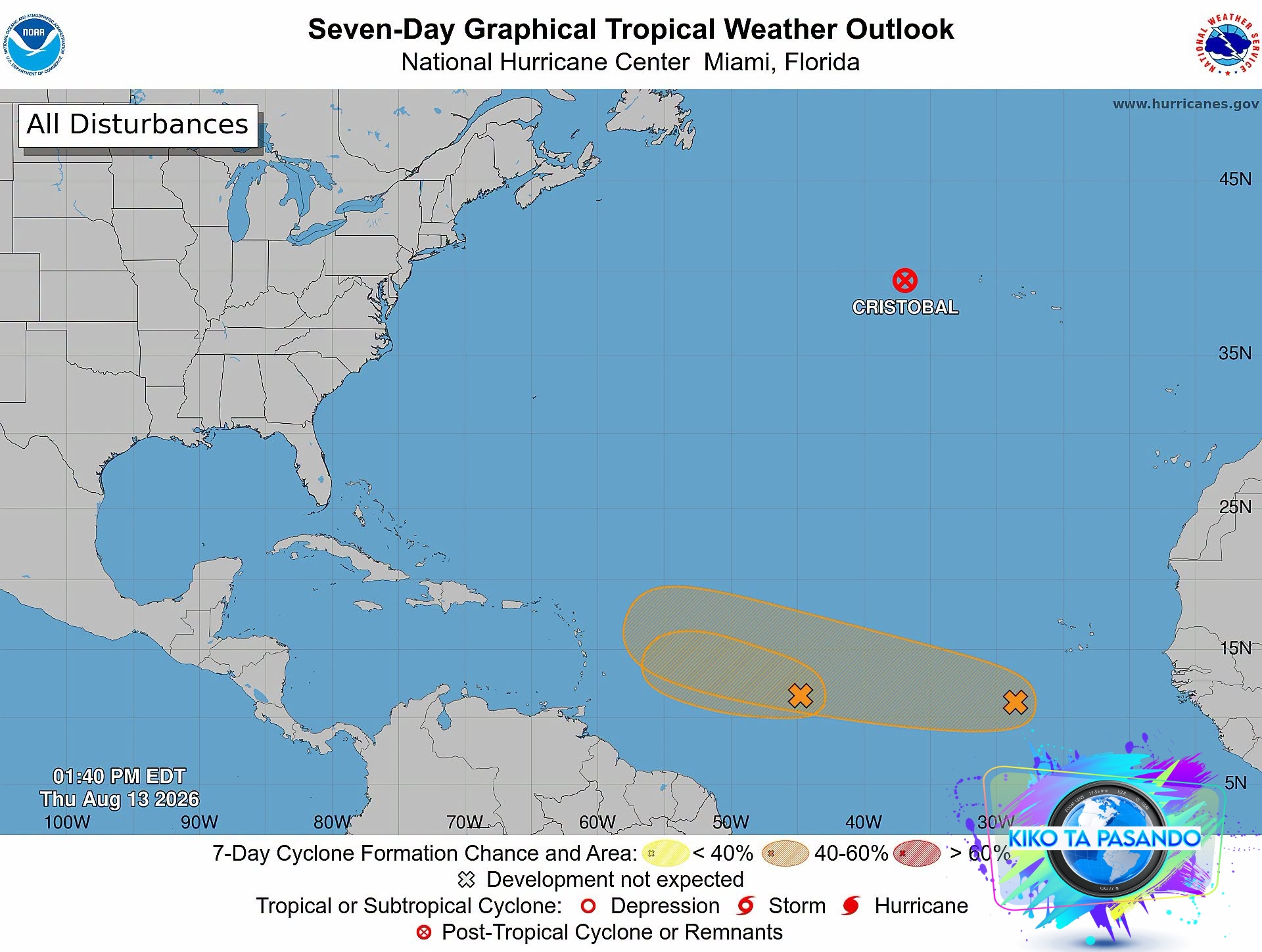
E disturbio tropikal situá ost di Antia Menor ta sigui move den direkshon wèst a traves di Atlántiko sentral. Durante e último oranan, e sistema a mustra un bahada den organisashon di nubia di áwaseru fuerte i kondishonnan ambiental a bira ménos faborabel pa mas desaroyo. Komo resultado, e probabilidat di formashon di siklon a wòrdu bahá na 40%. Miéntras ku un depreshon tropikal por forma ainda promé ku e disturbio yega Antia Menor, ta antisipá ku oumento di bientu na nivelnan haltu di atmósfera i e presensia di aire seku di Sahara lo limitá intensifikashon signifikante.
Sin importá desaroyo, e sistema lo trese periodonan di bientu fuerte i áwaseru lokalmente pisá na porshonnan di e parti sentral i nort di Antia Menor, manera Dominica, Martinique, Saint Lucia, Guadeloupe, Antigua i Barbuda, Saint Kitts & Nevis i Montserrat for di djabièrnè anochi pa durante di djasabra.
E parti sùit di Karibe, inkluyendo e Islanan ABC, ta keda pafó di e área prinsipal di impakto antisipá, ounke algu di e humedat rònt di e sistema por ekstendé pa sùit i kondishonnan stòf fini di Sahara por wòrdu opservá.
Servisio Meteorológiko Kòrsou lo sigui vigilá desaroyo di e sistema aki.
________________________________________________________
Update over tropische storing AL92
De tropische storing ten oosten van de Bovenwindse Eilanden blijft westwaarts over de centrale Atlantische Oceaan trekken. De afgelopen uren is de convectieve organisatie van het systeem afgenomen en zijn de omgevingsomstandigheden minder gunstig geworden voor verdere ontwikkeling. Hierdoor is de kans op cycloonvorming gedaald tot 40%. Hoewel er nog steeds een tropische depressie kan ontstaan voordat de storing de Benedenwindse Eilanden bereikt, zullen toenemende windschering en de aanwezigheid van droge Saharalucht naar verwachting een significante intensivering beperken.
Ongeacht de ontwikkeling zal het systeem van vrijdag tot en met zaterdag perioden met rukwinden en plaatselijk zware regenval veroorzaken in delen van de centrale en noordelijke Bovenwindse Eilanden, zoals Dominica, Martinique, Saint Lucia, Guadeloupe, Antigua en Barbuda, Saint Kitts en Nevis en Montserrat.
Het zuidelijke Caribisch gebied, inclusief de ABC-eilanden, blijft buiten het gebied waar de storing wordt verwacht, hoewel een deel van het omringende vocht zich zuidwaarts kan uitbreiden gecombineerd met heiigheid.
De Meteorologische Dienst van Curaçao zal de ontwikkeling van deze omstandigheden blijven volgen.
_____________________________________________________
Update on Tropical Disturbance AL92
The tropical disturbance located east of the Lesser Antilles continues to move westward across the central Atlantic. During the past several hours, the system has shown a decrease in convective organization and environmental conditions have become less favorable for further development. As a result, the probability of cyclone formation has been lowered to 40%. While a tropical depression could still form before the disturbance reaches the Lesser Antilles, increasing wind shear and the presence of dry Saharan air are expected to limit significant intensification.
Regardless of development, the system will bring periods of gusty winds and locally heavy rainfall to portions of the central and northern Lesser Antilles, such as Dominica, Martinique, Saint Lucia, Guadeloupe, Antigua and Barbuda, Saint Kitts and Nevis, Montserrat from Friday into Saturday.
The southern Caribbean, including the ABC islands, remains outside the main area of expected impact (formation ellipse), though some of the system’s surrounding moisture may extend southward and hazy conditions may be observed.
The Meteorological Department Curaçao will keep monitoring the development of these conditions.


639114718427035"
639114718427035"